Eastern Europe and Russia, AP World History p.2
Maps of Importance (evaluated with the Map Analysis sheet)
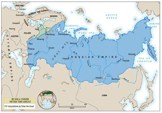
Russia Under Peter the Great
2. The map covers the eastern Europe and central/west Asia
3. The time period described by the map is 1689-1725
4. Russia before Peter the Great and Russian aquisitions by Peter the Great are marked because this map is to show what Peter the Great did for Russia.
5. The inset shown what part of the world we are looking at in a larger world context.
6. The Russian empire is shaded in blue, and the area in green is Peter the Great's acquisitons.
7. The symbols on the map are little black dots, which you all should know signify cities.
8. This map tells us what Russia under Peter the Great conquered. It is a good thing that he did conquer something, after all, he is Peter the Great ;)
And for those of you wondering why not that much of Poland has been conquered, there will be more to come under Catherine :)
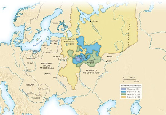
Poland-Lithuania and Russia
2. This map covers Eastern Europe and Western Russia.
3. The time period covered is 1300-1505.
4. Specific places marked include: Poland-Lithuania, the Duchy of Moscow, the Khanate of the Golden Horde, and the Republic of Novgorod. They are marked because they are the centers of civilization on this map.
5. There are no insets on this map.
6. The areas shaded are Moscow in 1300 (light blue), Expansion in 1389 (darker blue), Expansion in 1462 in green, and Expansion in 1505 in yellow.
7. Symbols used are little black dots, which everyone should know signify cities.
8. This map tells us the difference between Poland-Lithuania and Russia, in several different time periods. It starts back in the postclassical period, but ends in the beginning of the world shrinkage period, where Russia as we know it begins to form.
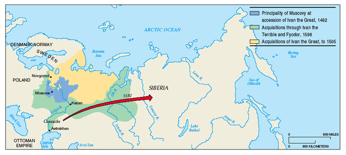
Russian Expansion Under the Early Tzars, 1462-1598
2. The map covers Poland, Northern Europe, Ottoman Empire, and Russia's entirety.
4. Specific places marked on the Map include various seas and rivers, the Ottoman Empire, Poland, Denmark, Norway, Sweden, and Siberia. They are marked mostly because they arei n the surrounding area of the expansion. Poland is especially important.
5. No insets are present.
6. The areas shaded are the Principality of Muscovy at accession of Ivan the Great, 1462 (blue), the Acquisitions through Ivan the Terrible and Fyodor, 1598 (green), and the Acquisitions of Ivan the Great, to 1505 (yellow).
7. The symbols uses are, as usual, little black dots to signify cities.
8. This map shows the direction of expansion of Russia. Notice it goes toward the east...did the Russians think that it would be easier to conquerer lesser territories than the established ones? Although that is unknown, it does look pretty suspicious.
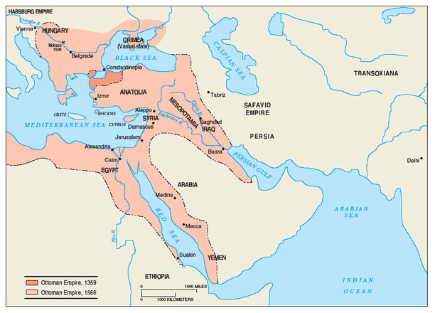
The Expansion of the Ottoman Empire
2. This map covers Eastern Europe and the Middle East
3. The time period described from the map is 1359-1566
4. Specific places marked on the map are the Savafid Empire, Persia, Ethiopia, Yemen, Arabia, Iraq, Mesopotamia, Egypt, Anatolia, Crimea, Hungary, and Syria. They are marked mostly because they are close by, but others are marked because they were conquered by the Ottomans.
5. There are no insets.
6. The dark pink shaded area is the Ottoman Empire in 1359, and the light pink area is the Ottoman Empire in 1566. The shading signifies beginning of the empire to close to the end of the empire.
7. The symbols used, as usual, are the little black dots which we all know are cities.
8. Holy cornflakes, the Ottomans sure did expand a ton in 200 years. Unfortunately, this is pretty much as far as they got because after this they started losing all their battles.
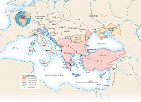
The Ottoman Empire
2. This map covers Eastern and Western Europe
3. The map covers an unknown time period, but it occured from 1450-1750
4. Specific places marked on the map include various seas and rivers, the Ottoman Empire, the Holy Roman Empire, Bohemia, Poland, Lithuania, Hungary, Transylvania, Moldavia, and Vedisan. These places are marked not only because they are close, but because they all are directly related with the Ottoman Empire. They all fought each other at some point.
5. The inset shows where in a larger world context we are looking.
6. The shaded areas are the Ottoman Empire (pink), the Ottoman Vassals (yellow), some sort of lane (blue) (sorry having a hard time deciphering the impossible to read type), and Cenorse lanes (green).
7. Major battles are marked with a black X, and little black circles are cities (obviously). The battles are located by the Black Sea
8. Overall, this map has showed how the Ottomans interacted with the territories around them.
Emily A., 2/18/11
